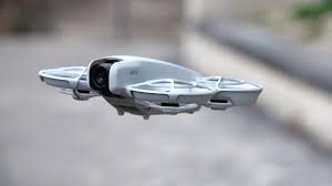
DJI’s Neo is surprisingly capable for a small drone, but it also has a few weaknesses — namely, a lack of vertical video and a relatively slow flight speed in tracking mode. The company has now addressed both of these issues with a new firmware update, adding vertical video and boosting the Neo’s tracking speed, among other things.
Given that the Neo is designed and priced for creators, the lack of vertical video was a big drawback. It can now handle it, although only at 1080p 60 fps at 9:16 and not 4K. This lower resolution is due to the fact that the camera gimbal doesn’t actually rotate 90 degrees like the Mini 4 Pro; instead, it shoots 4K horizontal resolution and then cuts off the edges.
Speed-wise, the Neo can now capture speeds up to 20 mph in tracking mode, up from about 12 mph previously. That’s actually faster than the Sport mode top speed of 18 mph, though it’s still much slower than the Neo’s maximum 36 mph in a fully manual setting (which requires the FPV Remote Controller 3). Still, it’s now up to the task of tracking slower-moving vehicles, especially bicycles.
Other new features include Goggles N3 support, LiveView stabilization with the Goggles N3 or Goggles 3, and improved noise reduction with the Mic 2. Unfortunately, DJI can’t do much about annoying propeller noise. To get the update, you’ll need to connect your Neo to DJI’s Fly app on Android or iOS, then update both the drone and the app.
DJI has removed its geofence that prevents users in the U.S. from flying over restricted areas like nuclear power plants, airports, and wildfires, the company wrote in a blog post on Monday. Starting January 13, areas previously called “restricted areas” or no-fly zones will be shown as “enhanced warning zones,” which correspond to designated Federal Aviation Administration (FAA) areas. DJI’s Fly app will display warnings about those areas, but will no longer prevent users from flying inside them, the company said.
In the article, DJI wrote that “the in-app alerts will notify operators flying near FAA-designated controlled airspace, putting control back in the hands of drone operators, consistent with regulatory principles of the operator bearing ultimate responsibility.” It added that technologies like Remote ID [introduced after DJI implemented geofencing] give authorities “the tools they need to enforce existing regulations,” DJI’s global head of policy Adam Welsh told The Verge.
Still, this update is an odd one, given that DJI is already in a shaky position in the US and could be banned from selling its products in the US as early as next year. DJI’s former head of policy, Brendan Shulman, criticized the move in several posts on Twitter. “Over the past few years there has been ample evidence that automated drone geofencing implemented using a risk-based approach has made a significant contribution to aviation safety,” he wrote.
There’s also a problem with drones weighing less than 250 grams. Those models were previously geofenced via GEO in restricted areas to prevent them from inadvertently flying in restricted areas. However, the update will remove that geofencing, and the remote ID on those lighter drones can be flicked out.
In fact, that’s exactly what happened last week when a DJI model weighing less than 250 grams damaged the wing of a Canadair Super Scooper airplane fighting the Los Angeles wildfires, causing it to temporarily stop working. That drone may not have been transmitting a remote ID, so the FBI said it would need to use “investigative means” to find the pilot.
DJI first implemented geofences (called GEOs) around airports in 2013, and added new zones in 2015 and 2016 after drones crashed on the White House lawn. It did so voluntarily, as the FAA only requires that operators be warned about restricted areas where flying is prohibited. However, now the responsibility for staying out of no-fly zones will be 100 percent on the operator.
“DJI reminds pilots to always ensure flights are conducted safely and in accordance with all local laws and regulations. For flights conducted in advanced warning areas, drone operators should obtain airspace authorization directly from the FAA and consult the FAA’s No Drone Zones resource for further information,” it wrote.